ANIMAL SAT NAV
When we travel by car, we use satellite navigation (sat nav) which uses the Global Positioning System (GPS) to tell us how to get to our destination. Now there are GPS tracking devices that collect information about the behaviour and movements of wildlife. From elephants to whales to birds and even insects, scientists are able to get information which helps in developing strategies to protect the animals. To do this, animals and birds are caught and fitted with a collar or a harness that is light enough for them to go about their normal life but contains a GPS device. At the click of a mouse, researchers can then follow the animals’ movements. Here are some current projects
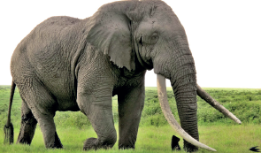
Endangered elephants
Elephants in Kenya travel enormous distances looking for food. However, this can cause problems for local farmers who sometimes kill these endangered animals because they have eaten the farmers’ crops. Tracking the movements of elephants with GPS has given conservationists information which has helped to improve interaction between humans and elephants.
Tiger tracking
GPS is also used to protect animals whose skin, fur, horns or meat is sold illegally for high prices. The World Wide Fund for Nature has fitted Bengal tigers in Nepal with GPS to protect them against poachers who hunt them.
Travelling turtles
The sea is an environment where we still have a lot to learn about animal behaviour. Researchers fixed GPS tracking to sea turtles’ shells. This has shown that sea turtles travel hundreds of kilometres on fixed routes.
Albatrossadventures
Albatrosses, the masters of the ocean, were among the first sea birds to be tagged. On their journeys to find food, albatrosses can fly up to 5,000 kilometres. They fly out on a zig zag path which they repeat exactly on their homeward journey to their nesting islands.
The cuckoo’s journey
In Britain, the first cuckoo song means spring has arrived. But this unmistakeable sound is getting very rare. So, biologists needed to know the route which cuckoos take during their 8,000-kilometre migration across Europe and into Africa. To find out, they created 5 satellite backpacks which they strapped to five birds, Clement, Martin, Lyster, Kasper and Chris. As the birds flew, the GPS emitted a radio signal which was picked up by a satellite. It was then sent to a laboratory in the UK where the route was mapped. Clement wasn’t keen on the British summer—after just a few weeks, he flew back to Africa!